
Understanding the Weather Dynamics
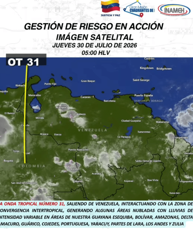
The National Institute of Meteorology and Hydrology (Inameh) has recently reported ongoing atmospheric instability across much of Venezuela. This condition is primarily associated with the departure of Tropical Wave N° 31, which is interacting with the Intertropical Convergence Zone (ITCZ), monsoonal troughs, and local convective effects. Such climatic events are crucial for understanding the broader environmental context of the region.
A Symphony of Clouds and Precipitation
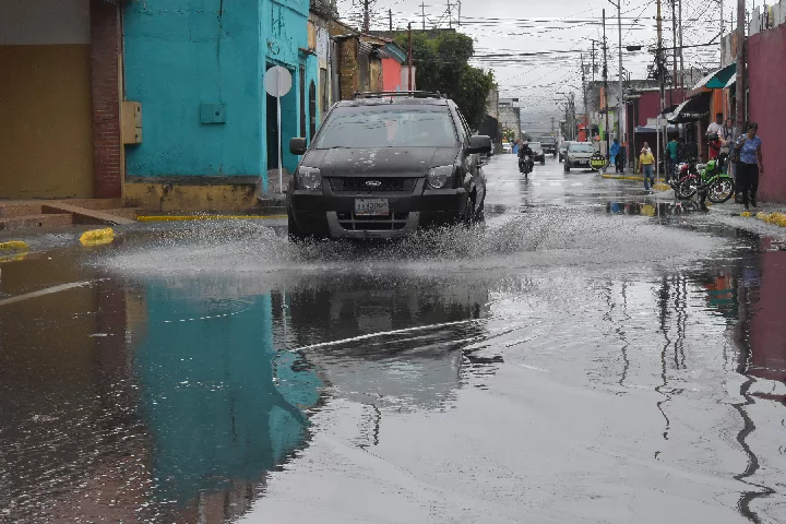
On a Thursday morning, the Venezuelan skies were characterized by partial to fragmented cloud cover. This atmospheric situation resulted in variable precipitation across several regions, with some areas experiencing thunderstorms. Notably, southern and central Venezuela, particularly regions like Guayana Esequiba, Bolívar, Amazonas, and Delta Amacuro, observed significant rainfall and electrical activity.
Regional Weather Impacts
As the day progressed, forecasts indicated a likelihood of increased cloud development, with varying intensity of rainfall expected throughout the afternoon and evening. Regions such as Monagas, Sucre, and the central and western plains, including the Andes and Zulia, were particularly highlighted for potential thunderstorms. Meanwhile, the coastal areas of central-northern Venezuela, inclusive of Gran Caracas, Miranda, and La Guaira, could anticipate lighter rain.
The Legacy of Tropical Waves
Tropical Wave N° 31, while moving away from the Venezuelan coastline, has left a mark, continuing to generate showers across the country. Predecessor N° 30 had already significantly impacted local weather patterns, emphasizing the need for vigilance in the face of these ongoing meteorological phenomena. Inameh remains vigilant in monitoring the situation as additional systems are anticipated in the coming weeks.
Precautionary Measures for the Public
Authorities are urging the public to remain cautious as the weather continues to evolve. Increased rainfall can lead to rapid river rises, landslides in mountainous areas, urban flooding, and potential disruptions to electrical services due to lightning strikes. The community is advised to stay informed and prepared for any sudden changes in weather conditions.
Looking Ahead: What’s Next?
As Tropical Wave N° 31 departs, attention turns to the anticipated arrival of Tropical Wave N° 32, expected to impact Guayana Esequiba between the weekend of August 1 and 2. As the tropical waves intersect with Venezuela’s diverse landscapes, their effects will continue to shape the weather narrative of the country. The interplay of these natural phenomena offers a vivid reminder of the intricate balance within our climate systems and the importance of staying informed.
Editorial note: This article was created by A Bit Lavish Miami’s Magazine as an original editorial reinterpretation based on publicly available reporting. Original source: efectococuyo.com. Read the original article here: https://efectococuyo.com/la-humanidad/inameh-reporta-lluvias-y-actividad-electrica-en-venezuela-por-salida-de-la-onda-tropical-n-31/.
Images are used for editorial reference with source credit. If an image requires correction or removal, please contact A Bit Lavish.










Dinorah Figuera: A Vision for Venezuela’s Institutional Renaissance
Dinorah Figuera returns to Venezuela with a commitment to reinstitutionalization, aiming to...
 2 Mins read
Vargas: Un Camino hacia la Reconstrucción Sostenible
Un análisis sobre el reciente acuerdo en Vargas para la reconstrucción post-sísmica,...
3 Mins read

Resilience Amidst Ruin: The Aftermath of Caraballeda’s Earthquake
Exploring the heart-wrenching impact of the recent earthquake on the educational community...
 ABL2 Mins read



Navigating the Waters of Dialogue: Venezuela’s Political Landscape in Flux
As Venezuela's political factions prepare for a critical dialogue, the return of...
ABL3 Mins read

Leave a comment